


VFRnav – Flight Navigation
وصف لـVFRnav – Flight Navigation
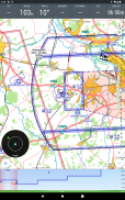
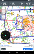
VFRnav هو تطبيق ملاحي مصمم خصيصًا لتلبية احتياجات الطيارين الذين يطيرون بموجب قواعد الطيران المرئي (VFR). يجمع التطبيق بين خريطة متحركة بأسلوب منظمة الطيران المدني الدولي (ICAO) مع ميزات التخطيط والتسجيل الشاملة، مما يتيح ملاحة طيران موثوقة وفعالة.
الميزات الرئيسية:
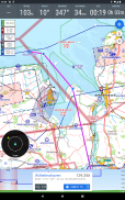
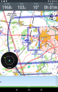
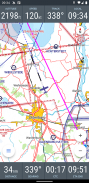
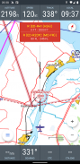
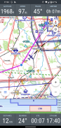
• التنقل على أساس الخريطة: يعرض مسارات الطيران على خريطة بنمط منظمة الطيران المدني الدولي (ICAO) مع تحديثات الموقع في الوقت الحقيقي.
• عملية دون اتصال: تعمل بكامل طاقتها دون اتصال بعد الإعداد. لا يلزم وجود اتصال إنترنت نشط أثناء الرحلة.
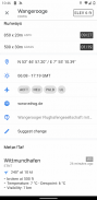
• قاعدة البيانات: معلومات شاملة عن المطارات ونقاط الطريق والمساعدات الملاحية عبر العديد من البلدان الأوروبية.
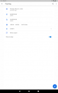
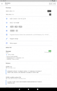
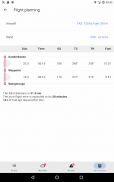
• تخطيط الطيران: يساعد في تخطيط الطريق، وحساب الوقود، وتقدير وقت الرحلة. يدمج بيانات الطقس وNOTAMS تلقائيًا للمسار المخطط.
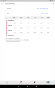
• سجل الطيران الرقمي: يسجل أوقات الإقلاع والهبوط تلقائيًا. تصدير بيانات الرحلة كملفات KML لاستخدامها في تطبيقات مثل خرائط Google.
• أجهزة الاستشعار الخارجية: تدعم التكامل مع أجهزة استقبال GPS الخارجية ومصادر بيانات حركة المرور (على سبيل المثال، FLARM، Stratux، CCAS، SafeSky، ADS-B) عبر WiFi أو Bluetooth.
المتطلبات الفنية:
• أندرويد الإصدار 5 أو أعلى.
• الحد الأدنى لدقة الشاشة 480 × 800 بكسل.
• ما لا يقل عن 200 ميغابايت من مساحة التخزين المجانية.
نموذج الترخيص:
يمكن اختبار VFRnav بالكامل دون قيود قبل الشراء. تبلغ تكلفة الترخيص 49.95 يورو وتوفر إمكانية الوصول إلى التحديثات المجانية لمدة عام واحد. بعد الفترة الأولية، يمكن تجديد مدة التحديث. يظل التطبيق يعمل بكامل طاقته بغض النظر عن التحديثات. التراخيص شخصية وصالحة لما يصل إلى ثلاثة أجهزة Android مرتبطة بحساب Google نفسه. ملاحظة: ترخيص أجهزة Android لا يمنح حقوق الاستخدام لأجهزة Apple.
تنصل:
لا يمكن ضمان دقة واكتمال المعلومات المقدمة. الاستخدام على مسؤوليتك الخاصة. يجب دائمًا التحقق من صحة البيانات المعروضة في التطبيق ومقارنتها بمخططات الطيران الرسمية.
VFRnav – Flight Navigation - معلومات APK
نُسخة APK: 4.11.0الحزمة: com.flugbetrieb.VFRnavآخر إصدار من VFRnav – Flight Navigation
نُسخ أخرى


تطبيقات من الفئة نفسها


